Moonee Valley Walking and Cycling Strategy: A Short Review

Moonee Valley City Council last voted last week to note the completion of the Moonee Valley City Walking and Cycling Strategy 2012-2022. While the council noted various achievements, there wasn’t much detail provided about what was accomplished and what hasn’t. (See the meeting minutes here, or a recording on YouTube here)

Importantly, Councillor Rose Iser successfully proposed an amendment to evaluate the past strategy, consult with organizations like MooneeBUG, use data to inform planning, and emphasize the importance of active transport.”

A Look Back at Moonee Valley in 2012

Moonee Valley was very different in 2012 when the strategy was envisioned. Escooters didn’t exist, it was 5 years before oBikes would come to Melbourne, and the first Moonee Valley Cycling and Walking Strategy 2004 was still in place (older draft strategies were never adopted).

The Strategy and Its Key Recommendations

The strategy, which spanned over 106 pages, including specific implementation plans, aimed to improve the walking and cycling infrastructure in Moonee Valley. Key recommendations included (among others):

  • Renew the Moonee Ponds Creek Shared Path and market it to new users.
  • Create a cycling and walking route parallel to the Craigieburn Rail corridor through signage, on-road symbols, and by improving crossings of major roads and allowing two-way bicycle traffic on one-way roads.
  • Advocate to VicRoads for full-time on-road separated bicycle lanes on Mount Alexander Road.
  • Work with VicRoads to install on-road bicycle facilities on Racecourse Road, Epsom Road, and others.
  • Develop a regular audit and maintenance program for shared paths and footpaths.

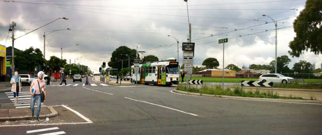
Image: Proposed Zebra crossings at the Epsom Road/Ascot Vale Road Roundabout (Image from the Strategy)

Progress and Challenges

While it is clear that many projects have increased the amenity of shared user paths, in particular, the Moonee Ponds Creek trail, and portions of the Craigieburn Cycling corridor have been built, there are still challenges. The Craigieburn cycling corridor, in particular, is subject to many crossings of state roads, and Moonee Valley still lacks safe arterial cycling routes. The on-road cycling network remains fractured.

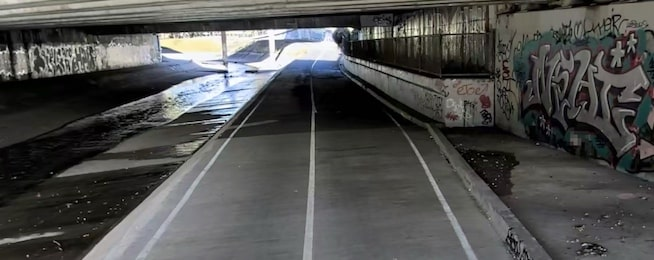
Image: Monee Ponds Creek Trail – Dark underpass that has had lighting installed.

Measuring Success on the Strategy

Measuring the success of the strategy is important, and it would be helpful to have more information on what has been achieved and what still needs to be done. While the council has noted the completion of the strategy, a more detailed report on the progress and challenges would provide a clearer picture of the state of walking and cycling infrastructure in Moonee Valley.

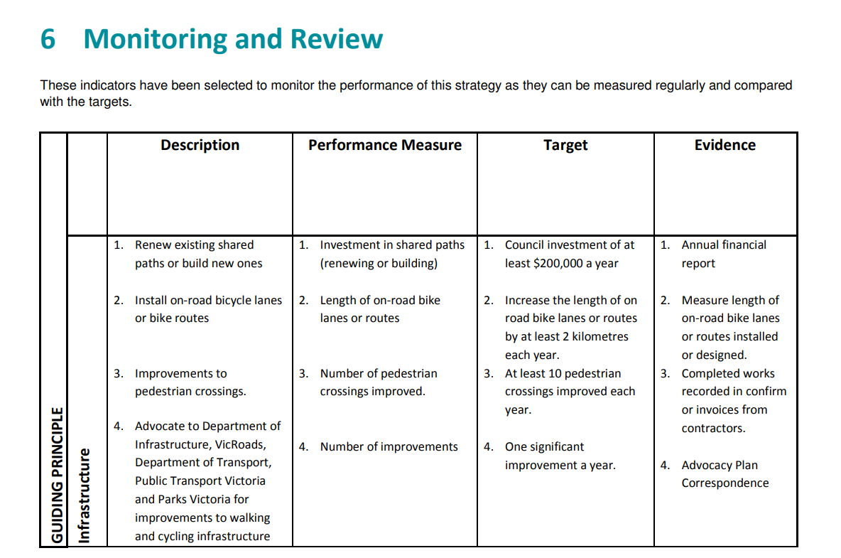
The strategy provided clear metrics for success, such as in the below sample, so it is quite unclear why Council was unable to report on them at the end of the strategy. I hope that it isn’t because they won’t like the answer!

Excerpt from the Walking and Cycling Strategy 2012-2022

What’s Next?

It appears that instead of another active transport strategy, the council is developing a holistic, 10-year Integrated Transport Strategy for the 2024/25 financial year, which will include public transport, cycling, walking, micromobility, taxis, and of course roads and parking.

There is a real risk that cycling doesn’t get dedicated treatment in this strategy the way it has in the past, however anecdotally the past strategies have not been successful, so combining the transport landscape may result in cycling benefiting from the increased funding and planning as local roads are considered in the same space.

MooneeBUG Newsletter (Jan 2024)

Happy New Year

Hi Everyone, My name is David (That’s me in the yellow) I’ve been living in Footscray, Essendon, and now Moonee Ponds for about five years and I love the area, but know that we have to shape our world to better and I hope you can help! (Or just open this email!)

MooneeBUG Meeting

I wanted to kick-off the year with a meeting at the Union Hotel in Ascot Vale at 7PM on Tuesday 6th February for those that are interested to discuss plans for the year, ways we can partner with council, vicroads, and other stakeholders, and potential projects to champion.

Please let me know by reply or hit attending on Facebook.

Facebook Page / Group and Mailing List Confirmation

For those that have been a member of the mailing list before this year, please fill out this form to let us know whether you live or work in the valley – this enables us to confidently say our membership represents X number of local residents. People outside the Moonee Valley area are still most welcome!

Please Like our Facebook Page and Join our Facebook Group

My ask: Help grow our profile (and leverage) making sure you like our page, and then forwarding this email to someone else that cycles in Moonee Valley!

BikeSpot

BikeSpot is a way to get meaningful data about dangerous, unsafe, or unsuitable cycling facilities. There are only two weeks remaining for for BikeSpot, and it is really easy to add spots on the map.

My ask: To help advocate for better cycling facilities, please find the time to add 5 spots (good or bad) on the map. Maybe the narrow bike path, the pothole, or the shared path with a dead-end.

Travancore Park Upgrade

Moonee Valley City Council resolved in late 2012 to build a new shared path in Travancore Park, Flemington.

This project was delayed due to the uncertainty of the East West Link project and more recently by the ongoing CityLink Tulla Widening works.

Council are pleased to announce that the shared path will be built in the coming months

Council will construct a new 3 metre wide separate concrete path with a centre line marking. This path, which will run along the edge of the Moonee Ponds Creek at the top of the embankment, will separate cyclists from walkers in Travancore Park.

Council will undertake several other improvements as part of the project:

  • Replace the existing chain mesh fence with a safer post and rail chain mesh fence.
  • Install a new barrier fence between the new shared path and the steep creek embankment for cyclist safety.
  • Create a new path link between Myrnong Crescent and the new shared path.
  • Realign the southern end of the internal path to allow more space between path users and dogs.
  • Relocate seating at the playground to a more shaded location.
  • Install an additional water fountain and relocate the existing drinking fountain and dog bowl to a more central location in the park.
  • Undertake tree planting and revegetation works.

While tree removal has been minimised in the design as much as possible, the shared path must be 3 metres wide – with no obstacles within 1 metre of either side – in order to meet standards which ensure rider safety and clear site lines. Council plans to replace trees that have to be removed with advanced native tree stock, and with species which are appropriate for rider safety, as well as for screening and habitat.

Travancore Park is an important area of open space and it was imperative to develop an outcome that is the right long-term decision for all park users. Council developed the final shared path alignment through an extensive stakeholder and community consultation process, including public meetings and ‘walkshops’ on site, as well as advice from an external reference group made up of local residents and organisations.

Council anticipate that works will commence in the next two months.

Western Ring Road Shared Path Closure.

VicRoads is managing a project to extend the noise walls on the Western Ring Road in Gowanbrae and Glenroy

They have closed the Western Ring Shared Path between Linacre Crescent bridge (Melway 6 D 12) and Gowanbrae Drive (Melway 16 A 3)

A detour route is in place using the Moonee Ponds Creek Shared Path under the Western Ring Road (Melway 6 E 11) to the bridge across to Adelaide Boulevard (Mel 16 D 2), along Primula Boulevard into Lanark Way, and Gowanbrae Drive.

This detour will apply for about three months when a shorter detour via Bush Mews (Mel 16 C 1) and Gowanbrae Drive will be in operation

Moonee Ponds Creek Shared Path Closure and Detour

Lend Lease is undertaking civil works for Transurban (CityLink) to construct a strengthening collar for the first pillar north of Racecourse Road.

This will involve excavation of the area to expose the pile cap below.

Due to the close proximity of the works, the shared path will be closed between Mt Alexander and Racecourse Roads for the duration of the works.


A detour will be in place around Boundary and Racecourse Roads with access available to the Flemington Bridge train station.

Temporary fencing will be erected with traffic controllers redirecting pedestrians/cyclists.

At this stage, they are looking at commencing preliminary works from Monday 30th Jan – 6th Feb 2017 with construction scheduled for the 10th – 14th March 2017.

Working hours will be from ~09:00-17:00.

Traffic management will be removed for after hours and set up the morning of each working day.

Temporary fencing will be repositioned to reopen the shared pathway outside of working hours.